|
|
|
|
|
|
|
Remote
Sensing Remote sensing is a way
of looking at objects or land features from a The sensor is either a conventional camera or a digital sensor. The conventional camera can have black and white, near infrared or true color film. Many aerial photos and all satellite images are produced with filmless electronic sensors. An electronic sensor measures the amount of electromagnetic radiation reflected from the Earth's surface. This spectral reflectance value is recorded and converted by a computer into colors or gray scale images to form a visual image on a display that appears similar to an aerial photograph. Sensors vary in sensitivity to different types of reflected radiation. Different sensors can respond to ultra-violet, visible blue, greed and red wavelenghts, near infrared, short-wave infrared, long-wave infrared and radar wavelengths. Micronet offers the following Value Added Remote sensing Services :
Benefits of these services :
Merge imagery with GIS/CAD/Map packages
|
|
Send mail to micronet@nagpur.dot.net.in with
questions or comments about this web site.
|


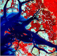 distance using a sensing device.
This distance can be a few hundred meters to thousands of kilometers. The sensor
is usually mounted in an airplane or in a satellite. The gives an accurate,
unbiased perspective of the land or water below and provides a historical record
of the effects of both human and natural activities. Remote sensing can be used
for such activities as environmental monitoring, urban planning, agriculture,
oil exploration, archeological exploration and mapping. Some sensors can detect
chemical composition of objects, changes in soil moisture and the health of
vegetation. Radar sensors detect human activities that cannot be sensed from the
ground and can "see" through clouds and fog.
distance using a sensing device.
This distance can be a few hundred meters to thousands of kilometers. The sensor
is usually mounted in an airplane or in a satellite. The gives an accurate,
unbiased perspective of the land or water below and provides a historical record
of the effects of both human and natural activities. Remote sensing can be used
for such activities as environmental monitoring, urban planning, agriculture,
oil exploration, archeological exploration and mapping. Some sensors can detect
chemical composition of objects, changes in soil moisture and the health of
vegetation. Radar sensors detect human activities that cannot be sensed from the
ground and can "see" through clouds and fog.